
Cleveland from Above: Spring 2025 Aerial Tour from Old Brooklyn to Downtown
When spring begins to stretch across the city of Cleveland, the landscape transforms—trees bud, lawns surge with color, and Lake Erie sheds its gray for a brighter shimmer. There’s no better time to take to the skies.
This spring, Propped Productions launched a panoramic visual project: a sweeping aerial journey from Old Brooklyn down West 25th Street toward the heart of Cleveland. Captured in high-resolution from a multi-battery drone session, the imagery brings together residential textures, infrastructure arteries, industrial memory, and the emerging green pulse of the season.
In this long-form breakdown, we unpack the process, the significance of the locations, and the role of visual storytelling in how we see the city. Let’s take flight.
Setting the Scene: Why West 25th and Old Brooklyn?
Old Brooklyn is more than just a neighborhood—it’s a threshold. Perched just south of downtown, it connects Cleveland Metroparks greenways with urban grid systems, residential sprawl with city skyline.
West 25th Street functions like a spine, running from the Cleveland Metroparks Zoo and Fulton Parkway all the way toward Ohio City and downtown. For decades, it has been a corridor of cultural shifts, traffic flows, and layered identity. From auto shops and scrapyards to playgrounds and historic bridges, the stretch offers a condensed survey of Cleveland’s past and future.
It’s a perfect line of flight.
Frame by Frame: Aerial Highlights & Descriptions
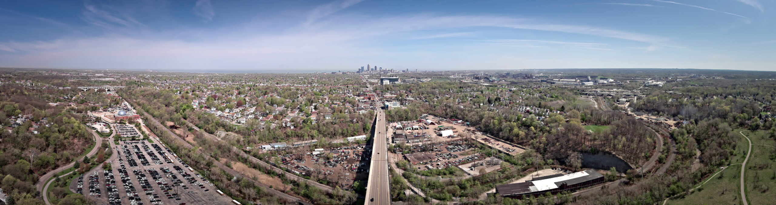
We broke this shoot into four major frames for Instagram, and one expansive panorama for Facebook, seen above. Each frame reveals a unique chapter in the story.
Frame 1: The Zoo & Fulton Parkway
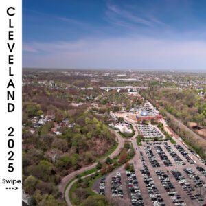
Starting just south of the city center, the first frame captures the Cleveland Metroparks Zoo parking lot, the round rotunda roof of the RainForest, and the curve of Fulton Parkway cutting through the canopy. Just beyond, you can see the Brooklyn Centre homes tucked into the hills.
Visual Anchors:
- Fulton Parkway winding through dense urban woods
- The Zoo’s dome and campus
- Cars packed into lots on a clear spring day
Frame 2: Scrapyards and Spine Roads
As the drone drifts north, the second frame enters the industrial midsection—home to long-established auto scrapyards and storage lots pressed up against the rapid transit corridor. The rail lines mirror the flow of traffic on West 25th, while houses press in from all sides.
Visual Anchors:
- Parallel roads and train lines
- Industrial zoning and mixed residential overlays
- Strong shadows from a high sun angle
Frame 3: The City Opens Up
Frame three marks a shift. The skyline comes into full view, Lake Erie presses against the horizon, and the vastness of the west side becomes visible. The shadow of the drone moves like a dot through the patchwork.
Visual Anchors:
- Downtown Cleveland in crisp profile
- West Side Market in the far distance
- Tree-lined neighborhoods dense and vibrant
Frame 4: Infrastructure and the Valley Floor
The final frame swoops lower across the industrial flats, where steel mills still mark Cleveland’s backbone. This is the working city—train yards, warehouses, the clustered energy of systems that keep Cleveland moving.
Visual Anchors:
- Smokestacks, warehouses, and railyards
- Intersections of residential calm and industrial power
- The curvature of the Cuyahoga River beyond
Panorama: A Complete Sweep
The stitched panorama puts it all together—an uninterrupted look from the Metroparks in the foreground to the skyline and lake in the distance. It’s both a spatial and emotional portrait: Cleveland as we know it and as we rediscover it each season.
What These Images Reveal About Cleveland in 2025
Cleveland isn’t static. From a distance, it may seem like a slow city—but above it, you can see the evidence of motion everywhere.
Construction sites pop up in frame one. New housing density emerges in frame three. Even the auto scrapyards, longstanding features of the valley, have restructured since previous flights.
Cleveland in 2025 is…
- Green where it once was gray
- Reclaiming industrial footprints
- Quietly reinventing itself through residential expansion
This flight became not just a documentation project, but a reflection on how infrastructure, nature, and people are layered across time.
Work With Us
Interested in capturing your project, neighborhood, or event from the sky?
Whether you’re looking to tell a story, highlight development, or build brand visuals—we’re here to help.